FishTrack provides saltwater anglers with everything they need to find fish. The FishTrack app offers free cloudfree sea surface temperature (SST) charts, global satellite imagery and marine weather forecasts – all in one layered tool.
With FishTrack you can:
- View the latest SST, chlorophyll and true color satellite imagery
- Overlay bathymetry, ocean currents and sea surface height
- Save waypoints to mark fishing spots and catches
- Create routes to plan a trip and view distances and headings
- View marine weather forecasts and tides/solunar tables
- Save fishing chart imagery for offline use
- View your current location both online and offline
Don't fish blind! FishTrack helps you plan a productive trip offshore. Burn less fuel and find fish faster.
We want to hear from you! Submit your questions or comments through our app to let us know what you think. If you'd like to speak directly with our customer service team, please e-mail us at: support@fishtrack.com.
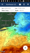
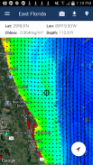
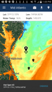
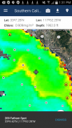
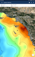
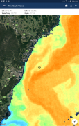
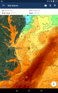
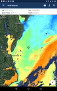
FishTrack предоставляет соленой воды рыболовы все, что нужно, чтобы найти рыбу. Приложение FishTrack предлагает бесплатно cloudfree температура поверхности моря (ТПМ) диаграммы, глобальные спутниковые изображения и прогнозы погоды морские - все в одном инструменте слоистый.
С FishTrack вы можете:
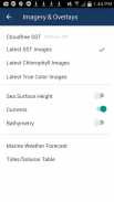
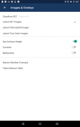
- Перейти к последнему SST, хлорофилл и истинный цвет спутниковых снимков
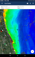
- Накладка батиметрия, океанические течения и поверхности моря Высота
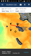
- Сохранить путевые точки, чтобы отметить места для рыбалки и улова
- Создание маршрутов планировать поездку и просматривать расстояния и заголовки
- Просмотр прогнозов погоды и морских приливов / солнечно-лунному календарю
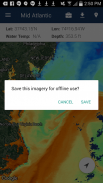
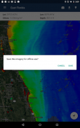
- Сохранение карты рыбалки изображения для использования в автономном режиме
- Просмотр текущего местоположения как онлайн, так и в автономном режиме
Не слепая рыба! FishTrack поможет вам спланировать продуктивную поездку на море. Сжигать меньше топлива и найти рыбу быстрее.
Ждем вашего ответа! Представьте свои вопросы или комментарии через наше приложение, чтобы сообщить нам, что вы думаете. Если вы хотите поговорить непосредственно с нашей службой поддержки клиентов, пожалуйста, напишите нам по адресу: support@fishtrack.com.
FishTrack provides saltwater anglers with everything they need to find fish. The FishTrack app offers free cloudfree sea surface temperature (SST) charts, global satellite imagery and marine weather forecasts – all in one layered tool.
With FishTrack you can:
- View the latest SST, chlorophyll and true color satellite imagery
- Overlay bathymetry, ocean currents and sea surface height
- Save waypoints to mark fishing spots and catches
- Create routes to plan a trip and view distances and headings
- View marine weather forecasts and tides/solunar tables
- Save fishing chart imagery for offline use
- View your current location both online and offline
Don't fish blind! FishTrack helps you plan a productive trip offshore. Burn less fuel and find fish faster.
We want to hear from you! Submit your questions or comments through our app to let us know what you think. If you'd like to speak directly with our customer service team, please e-mail us at: support@fishtrack.com.